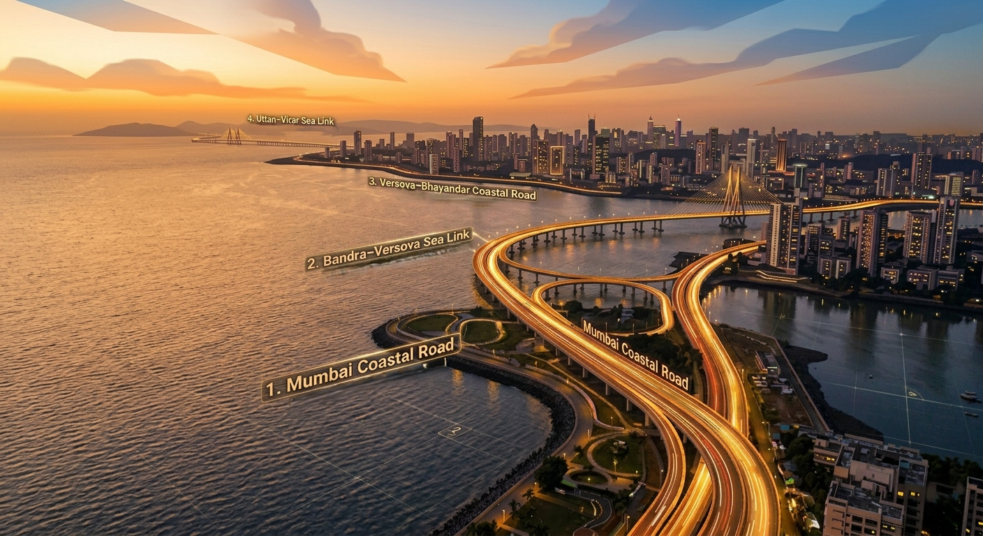
Mumbai's Coastal Road Network combines four mega-projects: the Mumbai Coastal Road, the Bandra–Versova Sea Link, the Versova–Bhayandar Coastal Road, and the Uttan–Virar Sea Link. When completed, the corridor will create a signal-free route from Nariman Point to Virar — spanning approximately 110-140 km along Mumbai's western seafront.
Phase 1 of Mumbai Coastal Road Now OpenThe 10.58 km Marine Lines to Worli section opened in January 2024 — the first segment of the eventual 110-140 km coastal corridor to become operational.
FEATURED PARTNER
ADVERTISEMENT
Want Your Brand Featured Here?
Reach thousands of decision-makers and investors searching for infrastructure projects every month.
Mumbai's road network has historically been constrained by its peninsula geography — funneling millions of commuters onto a handful of arterial roads. The Western Express Highway carries near-impossible loads, with average speeds often below 20 km/h at peak hours.
The Mumbai Coastal Road Network creates an entirely new north–south corridor along the city's western seafront, bypassing the dense interior urban grid. By combining reclaimed land, undersea tunnels, open-sea bridges, and coastal viaducts, it adds genuine capacity without displacing communities.
When all four segments are operational, the journey from Nariman Point to Virar — currently 90+ minutes — will take under 45 minutes via a continuous signal-free coastal expressway.
Current peak travel time (Nariman Point–Virar)90–120 min
Projected corridor travel time<45 min
Population directly benefited~8–10 Million
Frequently Asked Questions
Mumbai Coastal Road Network — FAQ
The Mumbai Coastal Road Network is an integrated corridor of four coastal infrastructure projects — the Mumbai Coastal Road, Bandra–Versova Sea Link, Versova–Bhayandar Coastal Road, and Uttan–Virar Sea Link — that together form a continuous signal-free expressway connecting Nariman Point in South Mumbai to Virar in the north. The full corridor spans approximately 140 km.
As of 2026, Phase 1 of the Mumbai Coastal Road (10.58 km from Marine Lines to Worli) is the only section open to public traffic. It was inaugurated in January 2024. All other segments are under construction or in planning stages.
The Mumbai Coastal Road Network will be completed in phases over the coming decade. The Mumbai Coastal Road Phase 2 targets ~2027. The Bandra–Versova Sea Link targets ~2028–2030. The Versova–Bhayandar Coastal Road and Uttan–Virar Sea Link are approved or in planning, projected for the early-to-mid 2030s.
The primary implementing agencies are MMRDA (Maharashtra Metropolitan Region Development Authority) and MCGM (Brihanmumbai Municipal Corporation). MMRDA is the lead agency for the sea links and coastal road extensions, while MCGM executed the Phase 1 section of the Mumbai Coastal Road.
The Mumbai Coastal Road Network is a connected system of coastal road, sea-link and approach-road projects planned or being developed along Mumbai's western coastline. It includes the operational South Mumbai Coastal Road, the under-construction Bandra–Versova Sea Link and Versova–Bhayandar Coastal Road, and the approved Uttan–Virar Sea Link Phase 1. These are separate projects implemented by different agencies but are intended to improve north–south coastal connectivity.
The broader Mumbai coastal road route runs broadly from South Mumbai through Worli and Bandra toward Versova, then continues through the northern western suburbs toward Bhayandar, Uttan and Virar through separate coastal-road and sea-link projects. The exact alignment varies by project because the network combines reclaimed-road sections, tunnels, bridges, elevated roads and sea links rather than forming one single road.
The currently developed coastal corridor begins in South Mumbai around Marine Drive and extends northward through Worli, Bandra and Versova. Future northern connectivity is being extended through the Versova–Bhayandar Coastal Road and Uttan–Virar Sea Link Phase 1 toward Virar. Therefore, there is no single officially defined start-to-end length for the entire Mumbai Coastal Road Network.
The Mumbai Coastal Road Network map should be understood as a combined view of several separate project alignments. The South Mumbai Coastal Road runs from the Marine Drive area to the Worli end of the Bandra–Worli Sea Link, while the Bandra–Versova Sea Link continues toward Versova. The Versova–Bhayandar Coastal Road then provides a northern connection toward Bhayandar, with the Uttan–Virar Sea Link Phase 1 extending the planned corridor toward Virar.
There is no single officially approved total length for the entire Mumbai Coastal Road Network. The principal components have different project scopes and include overlapping connectors and approach roads. For example, the South Mumbai Coastal Road is 10.58 km, the Bandra–Versova Sea Link is 17.17 km including connectors, the Versova–Bhayandar project has a 26.32 km linear road length and 33.40 km aggregate length including connectors and ancillary structures, while Uttan–Virar Sea Link Phase 1 is 55.12 km.
The Mumbai Coastal Road Network does not have one definitive project cost because its major sections are separately sanctioned and implemented. Current reported costs include ₹18,120.96 crore for the Bandra–Versova Sea Link, about ₹18,263 crore in civil works cost excluding GST for the Versova–Bhayandar Coastal Road, and about ₹58,754.71 crore for Uttan–Virar Sea Link Phase 1. These figures should not be combined into a single network cost without defining the exact scope and accounting basis.
The principal western coastal corridor projects include the South Mumbai Coastal Road, Bandra–Versova Sea Link, Versova–Bhayandar Coastal Road and Uttan–Virar Sea Link Phase 1. Additional connectors and related infrastructure, including the Bandra Fort connector to the Versova–Bandra Sea Link, are also being developed to improve integration between individual sections.
The network is at different construction stages rather than having one overall status. The South Mumbai Coastal Road is operational. The Bandra–Versova Sea Link is under construction and had reached about one-third completion by May 2026. The Versova–Bhayandar Coastal Road is under construction, while Uttan–Virar Sea Link Phase 1 is in the approved/pre-construction and land-acquisition stage.
No. Only the South Mumbai Coastal Road section is operational as part of the broader coastal corridor. Major northern links, including the Bandra–Versova Sea Link and Versova–Bhayandar Coastal Road, are still under construction, while Uttan–Virar Sea Link Phase 1 has not yet reached full construction.
Major 2026 developments include continued construction of the Bandra–Versova Sea Link, whose revised project cost is ₹18,120.96 crore and whose target completion is May 2028; ongoing construction of the Versova–Bhayandar Coastal Road; and land acquisition for Uttan–Virar Sea Link Phase 1. In September 2026, Maharashtra also approved a ₹1,722.40 crore connector linking the Bandra Fort end of the Versova–Bandra Sea Link with the Savarkar Sea Bridge.
The network is intended to create additional north–south capacity along Mumbai's western side, reducing dependence on heavily congested inland routes such as the Western Express Highway, Link Road and SV Road. Its combination of coastal roads, tunnels, elevated sections and sea links is designed to provide more direct movement between South Mumbai and the western and northern suburbs.
The Bandra–Versova Sea Link is a key middle section of the broader western coastal corridor. It connects the Bandra side with Versova and is intended to connect with the Mumbai Coastal Road system at its southern end and the northern coastal-road system toward Dahisar and Bhayandar. A separate ₹1,722.40 crore Bandra Fort connector has also been approved to improve access between the sea link and central Bandra.
North of Versova, the corridor is being developed through separate projects rather than one continuous construction package. The Versova–Bhayandar Coastal Road provides the coastal connection toward Bhayandar, while the approved Uttan–Virar Sea Link Phase 1 provides a further connection toward Virar through its 55.12 km system of sea link and approach roads. The Uttan–Virar project has also received in-principle approval for a connection to the Delhi–Mumbai Expressway near Virar.
The northern alignment is being developed through the Versova–Dahisar/Bhayandar corridor and onward toward Uttan and Virar. The Versova–Dahisar section uses a combination of elevated, stilt and tunnel infrastructure, while the wider Versova–Bhayandar project includes major structures such as bridges and tunnels. Uttan–Virar then extends the planned coastal connectivity toward Virar through a separate sea-link and connector system.
There is no single completion date for the entire Mumbai Coastal Road Network because its components have separate schedules. The South Mumbai Coastal Road is already operational. The Bandra–Versova Sea Link is targeted for May 2028, while the Versova–Bhayandar Coastal Road has been targeted for completion around the end of 2028. Uttan–Virar Sea Link Phase 1 is at an earlier implementation stage, so a reliable overall network completion date should not be stated.